Aries Shipping Agency - Constanta
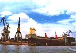
GALATI PORT
Geographical position
Lat: 45°25'N Long: 028°05'E
Location
The Port of Galati is the main Romanian river - maritime port on the Danube. It is situated on the left border of the Danube between Km 160 and Mm 76.
Anchorage
The anchorage zones are established between Mm 76 - Mm 78.5, Km 155 - Km 158 for the seagoing and river vessels and between Mm 80 - Km 150 and Km 158.2 - Km 159.3 for the empty river vessels.
Winter Lakes
The winter lakes are located in the Docuri Harbor and in the New Basin Harbor.
Port Sectors
The Port of Galati has four main specialized sectors: - Mineral Port - located within Km 155.4 and Km 157.6.It is specialized for ore, coal, coke, limestone rolled goods. - Old Commercial Port located within Km 149.34 and Km 151. It is specialized for passengers and ballast traffic. - Docuri Basin located within Mm 80 and Km 149.35. It is specialized for general cargo, bulk and cereals. - New Basin located within Mm 78+1300 and Mm 79+700 It is specialized for timber, rolled goods, ore, coal and coke.
Meteorological Information
Very hot summers and cold winters characterize the lower Danube basin. Maximum summer temperatures vary between + 35°C and +40°C and average summer temperatures are between +25°C and +22.4°C. Minimum winter temperatures vary between - 20.2°C and - 28.6°C and average winter temperatures vary between - 5.7°C and -1.7°C. Prevailing winds are from the North - Northeast and Southeast during winter and spring months. Average wind velocity is between 1 and 4m/sec. Wind velocity 10 to 15 m/sec occur between 1% and 5% of the time. Snowfall is not uniformly distributed but varies between 50 and 80 cm for approximately 30 days / year. Fog (particularly during cold periods) an average 55 days / year.
Partial freezing of the river can commence in January and usually ceases in February. However no freezing has been recorded in the past five years. It is reported that current velocities in the river vary between 2.29 and 2.36 Km / hr for medium water levels and between 5.95 and 6.04 km / hr during flood levels.
Water Levels
It is understood the reference level adopted to determine the minimum depth of the Danube is the navigation and training works Low Water Level (L.W.L), which is the level, exceeded for 94% of the time for the entire navigable length from Regensburg to Sulina.
Navigation from the river mouth to Galati is defined as Fluo Maritime and the minimum depth at 94 % L.W.L is defined as 7.32m
At Galati the level "0 " on the gauge scale is 0.86 m above Black Sea Datum and it is reported that during spring floods (snow melting period) the water level in the river can rise to 7.30 m above Black Sea Datum.
From the water data it would seem that make maximum use of water depths in the river downstream of Galati the minimum depth of water to be provided at the new berths should be 7 m. The maximum water depth during spring floods would then be in excess of 13.5 m.
Terminals and Berth details
| Measure | Mineral Port | Old Commercial Port | Docuri Basin | New Basin | |
|---|---|---|---|---|---|
| Berth | No. | 1-16 | 11-13, 18-21, 7-10,15-17,22 | 23-33 | 36-50 |
| Length of the quay | M | 2,000 | 1,677 | 1,365 | 1,980 |
| Depth (min) | M | (-4) - (-7.3) | -3.5 | -6.5 | -6.0 |
| Equipment - quay cranes | Pcs. | 42 | - | 17 | 10 |
| Platform area | Sq. m. | 44,380 | 8,220 | 38,100 | 167,730 |
| Vessels Capacity | Tdw | 25,000 - 3000 | - | 8,000 | 8,000 |