Aries Shipping Agency - Constanta
MANGALIA PORT
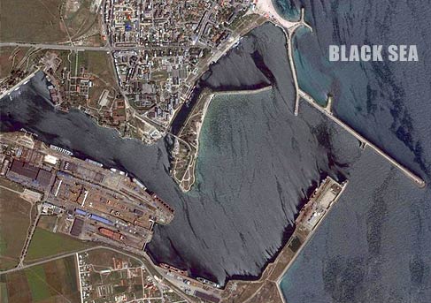
The Port of Mangalia is situated on the Black Sea, close to the Southern border with Bulgaria, and over 260 km N of Istanbul. It has an area of 142.19 ha of which 27.47 ha is land and 114.72 ha is water.
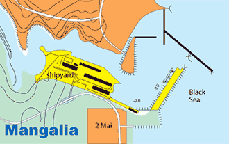
The N and S breakwaters have a total length of 2.74 km. There are 4 berths (2 operational berths) with a total length of 540 m. The max. depth is 9 m.
Traffic figures 2004:
209 thousand tons
Main cargoes:
iron ore; oil products; mineral products.
Load Line zone:
Summer
Communications:
VHF: Ch 16 and 14
General notices & regulations:
Vessels carrying toxic materials, explosives and inflammable materials are prohibited from entering the roadstead and port.
Foreign vessels are prohibited from entering the N basin, Mangalia Lake and the channel connecting the basin to the lake.
Sea buoys, fairways and channels:
From the vicinity of position 43°48'N 028°50'E the recommended approach route leads due W for 9nm to the harbour entrance, passing S of the harbour entrance light buoy (starboard hand) (0.25nm SE of NE breakwater head), then S of NE breakwater, the SE extremity of which is marked by a lighthouse (cupola on grey metal framework tower, 21m in height) and into Mangalia harbour the entrance of which is marked by lights (cupola on grey stone and concrete dwelling, 13m in height).
Caution: Attention is drawn to a rock, with a depth of 0.4m over it, that lies 0.2nm S of the SE breakwater head.
Pilot:
Compulsory. Vessels should send request for pilot at least 2 hours before:
1. Arrival in the roads
2. Moving within the port
3. Leaving the port
Anchorages:
Anchorage is available in the roads 1.5 nm NE of the harbour entrance. The anchorage area has depths of 17-22 m.
Tidal range and flow:
Range 0.3 m. Current: In normal weather the current sets S off the harbour entrance at a rate of 0.5 km. The current extends for approx 3 nm offshore where its outer limit can be distinguished, as the water forming the current is darker in color.
Dock density:
1025
Weather:
Prevailing winds: Variable.
Principal lights:
| Location | Characteristics | Range (nm) | Structure/Height(m) |
|---|---|---|---|
| Mangalia Main Light: 43°48'.7N 028°33'.6E |
FI (2) W5 5s | 22 | White pyramidal stone tower (42) |
| Entrance Light NE Breakwater Head 43°47'.9N 028°36.1'E | FI W 4s | 10 | Cupola on grey framework tower (21) |
Charts:
BA 2230, 2282, 2284. Admiralty Pilot NP24.
Tugs:
1x600 HP and 1x2,400 HP If more tugs are required the can be supplied from Constanta.
Berths Information:
| Berth | Length (m) | Max depth (m) | No of berths | Location |
|---|---|---|---|---|
| General cargo | 419 | 9.0 | 2 | berth 1, 2 |
| Technical Vessels Berth | 105 | 5.5 | 1 | berth 4 |
| Fitting-out Berth | 95 | 5.5 - 9.0 | 1 | berth 3 |
Facilities:
Quay cranes available: 1 x 120t, 3 x 50t, 1 x 15t, 4 x 6.3t.
Storage:
Open storage of 20,000 sq.m and covered storage of 4,300 sq.m available.