Aries Shipping Agency - Constanta
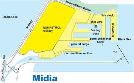
MIDIA PORT
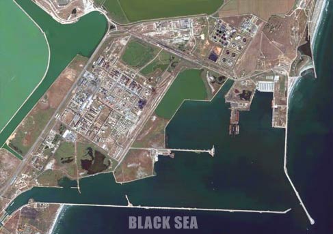
The Port of Midia is located on the Black Sea coastline, approx 13.5nm N of Constanta. It is one of the satellite ports of Constanta and was designed and built to serve the adjacent industrial and petrochemical facilities.
The N and S breakwaters have a total length of 6,97 m. The port covers 833,9 ha of which 233,7 ha is land and 600,1 ha is water. There are 14 berths (11 operational berths, 3 berths belong to Constanta Shipyard) with a total length of 2,24 km.
Further to dredging operations performed the port depths are increased to 9 m at crude oil discharging berths 1-4, allowing access to tankers having a 8,5 m maximum draught and 20.000 dwt.
Traffic figures 2004:
1,066 thousand tons
Main cargoes 2004:
Oil products and natural gas; crude oil; iron ore; lime, cement, construction materials; live stock.
Connections :
road, railway, inland ( via Poarta Alba-Midia Navodari Canal)
Communications:
Radio Constanta, callsign ”YQI”, working frequency: 500kHz; 461kHz; 2,748kHz. VHF: Harbour Master, Midia, Ch 67.
Health regulations:
Sanitary Inspection: Immediately after berthing, the Sanitary Commission checks the condition of health of all the personnel on board, the nature of cargo, specifications regarding possible diseases, vaccinations, etc. If there is no contamination danger, free pratique is granted to the vessel.
Port limits:
The port is limited by the S and E breakwaters
Sea buoys, fairways and channels:
The port is accessed through an approach channel with a width of 80 m and a depth of 5.6m.
Pilot:
Compulsory for all vessels, except Navy vessels, vessels used for a public service such as maintenance, control and surveillance of navigation, salvage vessels, training, hospital and leisure vessels. Pilotage is compulsory for entering, leaving the port and for the maneuvering of the vessels inside the port, throughout 24 hours. The vessel's Master has to notify pilots, at least 12 hours prior to arrival. The vessel's Master will contact Constanta Port State Control at the entrance into the zone of 12nm from the N jetty, calling on VHF Ch 14.
The compulsory zone to embark/disembark the pilot is as follows:
Fair weather (wind force 4), near the point of co-ordinates: 44°05'.1N 028°43'.1E.
Bad weather (wind over force 4), near the point of co-ordinates: 44°06'.2N 028°42'.3E.
The pilot boat is white, with ”pilot” on the side.
Anchorages:
Anchorage is available at the following co-ordinates:
The depth in the anchorage area is 20 m.
| Latitude | Longitude |
|---|---|
| 44°22'.0N | 028°45'.5E |
| 44°22'.0N | 028°48'.5E |
| 44°19'.5N | 028°45'.5E |
| 44°19'.5N | 028°48'.6E |
Tidal range and flow:
Tides in the Black Sea are negligible. Variations of water level may be caused by persistent winds and can reach 0.5m under extreme conditions.
Dock density:
1014
Weather:
Prevailing winds: Winter, N-NE; Spring, NE-E and NE-S; Summer, NW-NE; Autumn, N-NE.
Strong winds occur at the end of autumn (Oct) and in winter (Jan) with storms up to Beaufort force 9 to 10 (20kn to 30kn).
Main navigational aids:
Along the Romanian coast, from Midia to Mangalia there are modern navigational aids with solar cells, remote control and radar reflectors.
Principal lights:
| Location | Characteristics | Range(nm) | Structure/Height(m) |
|---|---|---|---|
| MidiaMain Light: 44°20'.9N 028°41'.1E |
FIW 5s | 17 | Whitecupola on a metal framework tower with red and white bands (22) |
| EntranceLight (offshore breakwater head) 43°47'.9N 028°36.1'E |
FIW 4s | 10 | Metalstructure on white concrete (18) |
Charts:
Admiralty Pilot NP24.
Restrictions:
Tankers are not permitted to enter at night
Tugs:
There is a tug of 600 hp available (owned by Black Sea Shipping). More tugs can be ordered from Constanta.
Coast guard:
There is a salvage group, with 2 tugs: ”Hercules” (6,600 hp) and ”Viteazul” (2,400 hp). The salvage group is able to act as coastguard along the Romanian Coast and in international waters.
Mooring information:
There are no unusual berthing maneuvers.
Berths Information:
| Berth | Length(m) | Maxdepth (m) | Cargo |
|---|---|---|---|
| 1- 4 | 532 | 9.0 | Crudeoil |
| 5- 8 | 637.6 | 9.0 | Livestock |
| 9 | 204 | 9.0 | Petroleumproducts |
| 10- 11 | 191.3 | 9.0 | Generalcargo |
| 3berths belong to Constanta Shipyard | Shipmaintenance and repair | ||
Facilities:
Quay cranes 2 x 6.5 t ( 1x 10t - Global Op.).
Storage:
Warehouses = 3 x 720 = 2.160 sq.m. and platform = 10.780 sq.m.
Barges:
There is a river-maritime access in the port via Danube-Black Sea Canal (Poarta Alba - Navodari branch).